
8/8/24 - 12 PM Tropical Storm Debby Update
The Dieter Company office has been and will remain open for normal business hours. All guests schedule to arrive or depart over the next several days should proceed as normal unless specifically told otherwise. Thankfully the rain for our area has been significantly less than predicted and few reported issues have been limited to leaks and screens blowing out.
Sandpiper Run & Crescent HOA Update
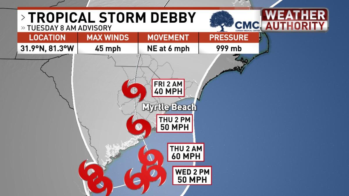
Tropical storm Debby is leaving the area and progressing to the north.
Property inspections were conducted this morning and the Association faired very well!
Please be advised, however, that the pool will remain closed until tomorrow morning.
Somerset – Fordham, Cambridge, Warwick, Hamilton, Paget, Whitney Parrish
With the winds and blowing rain subsiding late Thursday into Friday morning, we are optimistic that we can start bringing the elevators up early Friday morning.
Additional Updates will be posted and they are shared by the HOA
8/7/24 – 12:30 PM Tropical Storm Debby Update
Our area has been very fortunate so far and now we are waiting for the storm to pass through our area. While there have been several bands of heavy rain, the overall amount has been less than expected. We have even seen a few folks out walking on the beach during the moments of sunshine. These moments of sunshine have also given most of roads a change to drain and stay clear. We will be available to assist with emergencies if needed through the storm.
Per the town of Pawleys Island, there are 2 phases of the storm we are experiencing:
“Phase One: A continuation of heavy bands of periodic rain through Wednesday evening. While we have observed some standing water in some sections of roadway and in people’s driveways, thankfully the low tide level and periodic breaks in the rain are allowing the stormwater to properly recede.
Phase Two: Storm Surge Potential with a second landfall most likely as a tropical storm. The timing and location of that is still uncertain.
As the week progresses into Thursday the potential for storm surge along the coast increases. The timeframes that we will be monitoring closely are the high tide cycles at the following times:
Wednesday 11:00 pm, Thursday 11:51am, Thursday 11:30 pm
Thankfully our current tide levels are comparatively much lower than during King Tide periods that we often experience.
Summary recommendations (from the town):
-Please consider relocating your vehicle to a safe location off the island. A good time to do that would be on Tuesday or Wednesday morning. Be mindful of where you park and consider locating your vehicle a modest distance from roadside drainage ditches or stormwater ponds as the carrying capacity of these infrastructure systems will be stressed with the projected rainfall all along the Waccamaw Neck.
- If you begin to observe severe flooding on the roads it is best to remain where you are and not drive through a flooded roadway and risk being stranded.
- Be particularly mindful of the high tide cycles on Thursday and Friday.
Here is the latest from Ed Piotrowski at WPDE:
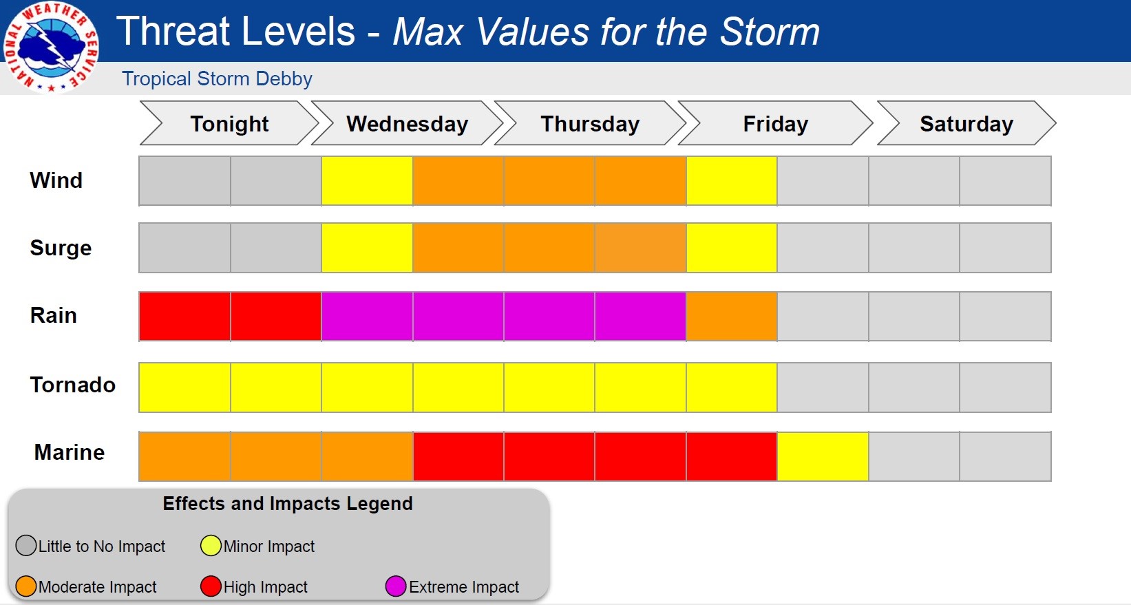
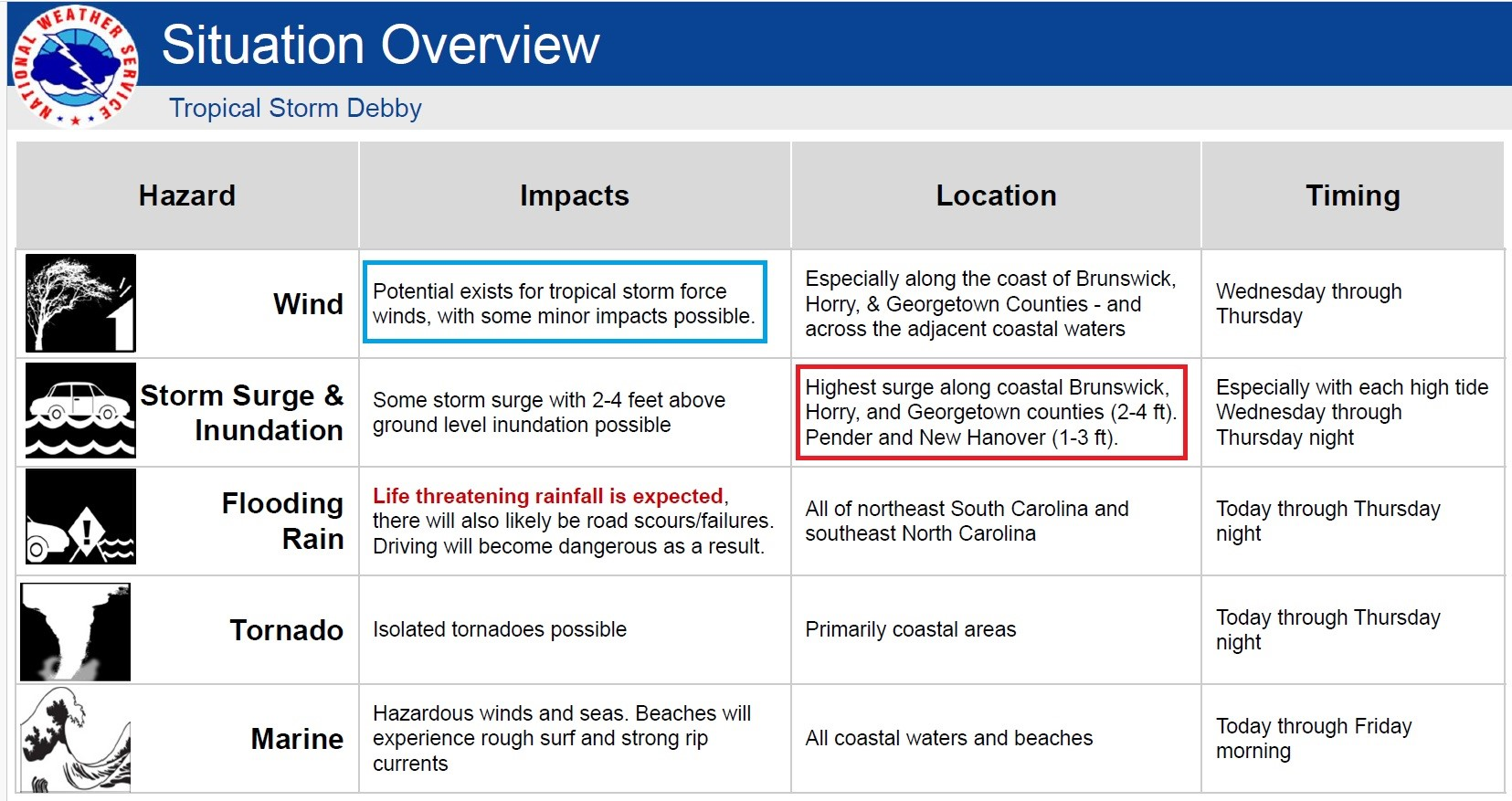
“We've been very lucky. Tropical Storm Debby ingested tons of dry air over the past 24 hours, which helped to cut down on extreme rain totals so far. That said, there WILL be rounds of extremely heavy rain. Here's a breakdown of what to expect.
TIMING - The worst of the weather is this afternoon through Thursday with conditions improving Thursday night into Friday. We're back to typical summertime weather Friday through the weekend.
RAIN - Satellite, radar and forecast models insist we'll see rounds of extremely heavy rain this afternoon through Thursday morning. The rain will be scattered but still heavy at times for the afternoon and evening. Most areas will receive an additional 4-8" of rain with isolated spots up near 10". Extreme flooding could occur in those areas that get persistent heavy rain. Flash flooding can lead to ditches and retention ponds overflowing, washed-out roads, and the possibility of water entering structures. Take flash flood warnings seriously!
WIND - The center of Debby will likely come ashore south of us overnight. Expect wind gusts of 25-35 today, 30-40 tonight, and 35-45 on Thursday. Winds will fall quickly Thursday evening and Friday. With all the rain and loose soil, a few trees could fall, and isolated power outages would be possible.
TORNADO - The tornado threat is very low and mainly confined to the coast today and tonight.
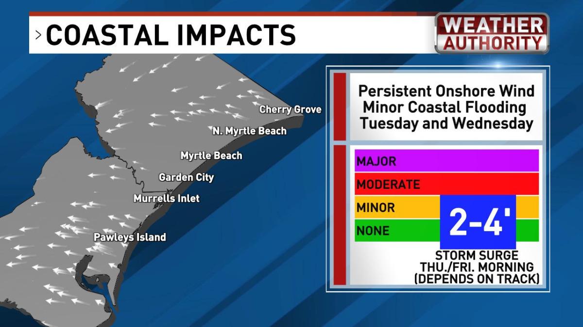
ALONG THE COAST—A prolonged period of onshore winds will produce rough surf, dangerous rip currents, and coastal flooding. A 2-4 ft. storm surge will come in rounds today and tonight around high tide at 10:10am Wednesday, 10:15pm Wednesday, 10:55am Thursday, and 10:56pm Thursday. Minor coastal flooding is expected, but nothing like previous hurricanes.
RIVERS - Area rivers will rise into moderate to major flood stage. Almost all rivers are expected to stay well below the levels reached in Hurricane Matthew and Hurricane Florence.
CAN YOU COME TO THE BEACH Friday and beyond? I think so, but keep in mind that there's no way to know right now how much flooding lingers and if there will be road closures & power outages. Check with SCDOT and NC DOT for road information”
Important Final Notes:
Power Outages should be reported to Santee Cooper 888-769-7688.
Cable Outages are likely and should be reported to Spectrum Support 843-913-7941
Internet Outages are also likely and should be reported to the service provider. Contact information is on your checkin package and property information located in the kitchen.
Please limit calls, but know that we are available to assist with emergencies.

8/6/24 - 12:30PM Tropical Storm Debby Update
Pawleys Island & Litchfield Beach are now under a tropical storm advisory. As expected flash flood, storm surge, and tornado warnings have been issued for the area, however, no evacuation order has been issued,
We are suggesting that guests relocate their vehicles to higher ground today through the high tide around noon on Thursday.
There have been Cable & Internet Outages throughout the area. Spectrum is aware of the problem and continues to work on getting it resolved.
Storm Preparation - Thank you to the many guests who helped with storm-prepping the property where they are staying. If assistance is needed, please let us know asap. This includes:
Ensure all windows, doors, and screened doors are locked/ latched.
Bring in lightweight outside furnishings. Turn heavy (or dirty) items so they will not blow away.
Place grill in storage if possible.
Private homes park elevators on the top level.
In the unlikely event power goes out, notify Santee Cooper 888-769-7688.
Thursday afternoon let us know if your rental experiences any damage from the storm.
Update from meteorologist Ed Piotrowski for our area –
“Debby's circulation is pointing a firehose of tropical moisture directly into our area. This strong wording from the National Hurricane Center says it all: "This potentially historic rainfall will likely result in areas of catastrophic flooding in parts of Georgia and South Carolina".
TIMING - The worst of the weather is now through Thursday with conditions improving Friday.
RAIN - Expect bands of extremely heavy rain Tuesday - Thursday. From today through Friday, most of the area will receive 10-15" of rain with isolated amounts near 20". Extreme flooding could occur in those areas that get persistent heavy rain. Flash flooding can lead to ditches and retention ponds overflowing, washed out roads, and the possibility of water entering structures. Take flash flood warnings seriously!
WIND - Gusts will range from 20-30 mph today and Wednesday but could gust between 35-45 mph later Thursday and Friday. Debby will emerge over the ocean later today or Wednesday and could regain some strength. If it spends more time there than currently expected and makes a second landfall near our area, winds will be higher...conceivably over 50 mph. Right now, most of the models show Debby moving inland south of us. With all the rain and loose soil, some trees could fall, and power outages would be possible.
TORNADO - A tornado watch is in effect for areas east of I-95 until 5pm. A tornado risk will exist for areas mainly near the coast Tuesday - Thursday.
ALONG THE COAST - a prolonged period of onshore winds will produce rough surf, dangerous rip currents and rounds of coastal flooding. In fact, we could see a storm surge of 2-4 feet Thursday or Thursday night.
Note that at this time there is no change for anyone that will be arriving later this week.
Please continue check our website for updates and changes.
Our favorite sources of information are:
https://spaghettimodels.com/ Consolidated weather information
https://www.nhc.noaa.gov/ National Hurricane Center
https://wpde.com/weather Local Weather Expert recent update below
https://www.facebook.com/EdPiotrowskiWPDE
We are reaching out to current guests and asking them to help with the following before by tomorrow afternoon. Contact us immediately if you need assistance and we are glad to help.
If properties are owner-occupied or vacant, let us know if you need assistance.
Ensure all windows, doors, and screened doors are locked/ latched.
Bring in lightweight outside furnishings. Turn heavy (or dirty) items so they will not blow away.
Place grill in storage if possible.
Private elevators in homes should be brought to the main floor.
In the unlikely event power goes out, notify Santee Cooper 888-769-7688.
* Condo HOA’s may shut down elevators if the wind requires it and will be back online as soon as it is safe.
* Some properties may experience flash flooding. We suggest moving vehicles to higher ground if needed.
Renters scheduled to check-in this week and next should plan arrive as scheduled unless other notice is given.
Breakdown of what to expect for our area according to WPDE, Ed Piotrowski:
RAIN - Expect bands of extremely heavy rain Tuesday – Thursday. From today through Friday most of the area will receive 8-16" of rain… Extreme flooding could occur in those areas that get persistent heavy rain.
WIND - Gusts will range from 20-30 mph most of the week but could gust between 35-45 mph later Thurs - Fri.
ALONG THE COAST - a prolonged period of onshore winds will produce rough surf, dangerous rip currents and rounds of coastal flooding. In fact, we could see a storm surge of 2-4 feet Thursday or Friday.
Specific HOA Info provided below. No notes, means that specific details have not been provided in that area.
Litchfield By The Sea
- Preparation and planning for access control systems to be protected including the removal of gate arms for the duration of the storm
- Litchfield Beach & Golf is allowing folks to use their parking lot. Please avoid the area to the left (where equipment is stored) – this area has been known to flood. The Beach House parking lot has been known to flood and that location is not recommended to leave your vehicles
Sandpiper Run & Crescent
In preparation for the storm, secure your balcony furniture, contact [The Dieter Company if assistance is needed].
- You may want to consider relocating your vehicles off-property, particularly the A Building homeowners.
- The pool amenity is being secured and pool water levels will be lowered to accommodate rainfall
- Luggage carts and trash cans will be secured
- Tomorrow the elevator company will park the elevators on the 4th floor
Somerset Condos – Fordham, Cambridge, Warwick, Hamilton, Paget, Whitney Parrish
-Please secure all patio furniture and [let The Dieter Co know if you need assistance].
- THE ELEVATORS WILL BE SHUT DOWN STARTING AT 10 AM TUESDAY. The elevators must be protected to avoid the potential of extreme expenses. The luggage carts will be locked in the lobbies, so if you plan on leaving the property, please ensure you have done so by 10 am.
-Based on the current weather predictions you may want to move your car as far from garage as possible. The front of Whitney Parish or higher ground may be a more favorable location however the choice is yours.
Helpful Contact Provided by The Chamber of Commerce
Town of Pawleys Island: The Town of Pawleys Island Police Department encourages residents and guests on the island to move vehicles to the mainland during the peak storm.
https://www.townofpawleysisland.com/https://www.facebook.com/TownofPawleysIsland
Please stay tuned to OFFICIAL sources for information including:
- Georgetown County Facebook
- Georgetown County Emergency Management Facebook
- Hurricane Debby pages on the County’s website
- Tidelands Health Facebook
- SC Emergency Management Division Facebook
- SC Emergency Management Website
- SC Department of Transportation Facebook
https://www.weather.gov/ilm/https://www.facebook.com/NWSWilmingtonNC


